Time-traveling through the San Francisco Bay tidal marshes
To ensure the future of the Bay, researchers are exploring its past and present ecosystems, Brittney J. Miller reports. Illustrations by Joshua Zupan and Hannah Kanne.
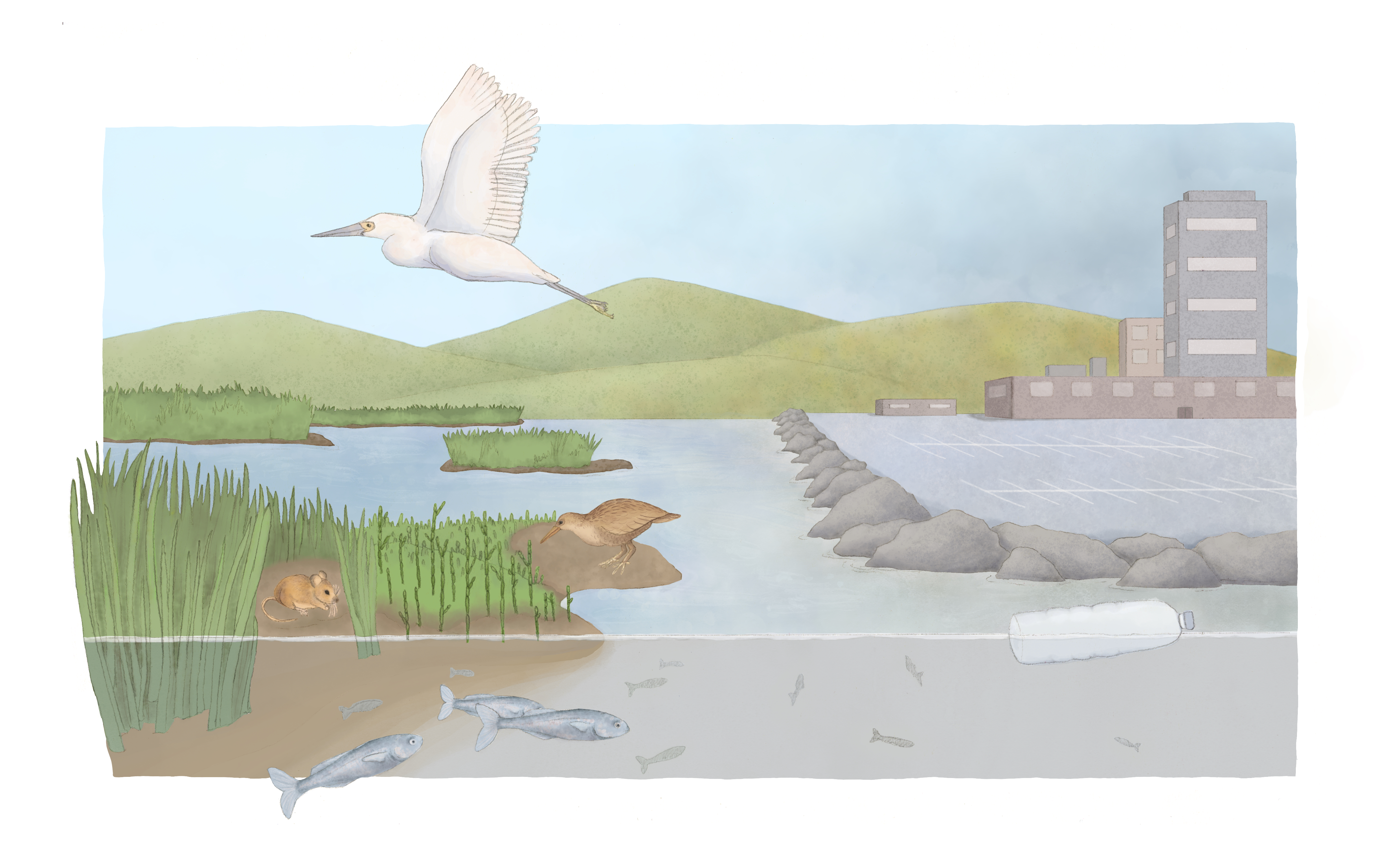
Illustration: Joshua Zupan
An undulating sea of green surrounded Miranda Melen. Her boots sunk deeper into the mud with every step; the slurp of each footfall reminded her to choose her path carefully, lest she lose a shoe to the sludge. Gnats clogged the air and low-lying plants dominated the brackish water that rose and fell depending on the tide.
Melen was wandering through was a tidal marsh — one of the few remaining in the San Francisco Bay after centuries of ecological abuse. The pocket of productive vegetation, swaying to the sounds of bird wings and whistling salty breezes, reminded her of the expansive habitats that marked these waters centuries ago.
“That’s what this ecosystem once was,” said Melen, now a Ph.D. candidate in the University of California, Santa Cruz’s Ecology and Evolutionary Biology Department. “We’ve done a lot to it since then. But the birds, the animals — that’s their livelihood there.”
As a former senior ecologist with the San Francisco Bay Bird Observatory, Melen spent three years exploring these tidal marshes, where freshwater and saltwater meet to create one of the most productive ecosystems in the world. Short mats of fast-growing plants adjust to fluctuating sediment levels, filtering pollutants and excess nutrients out of the Bay while harboring carbon and greenhouse gases that would otherwise contribute to global warming. These tidal zones represent habitat and food for hundreds of animal species, including the endangered salt marsh harvest mouse and ridgway’s rail. Their adjacent areas, called transitional habitat, link these intertidal locations to upland areas and provide essential foraging and coverage area for marsh critters.
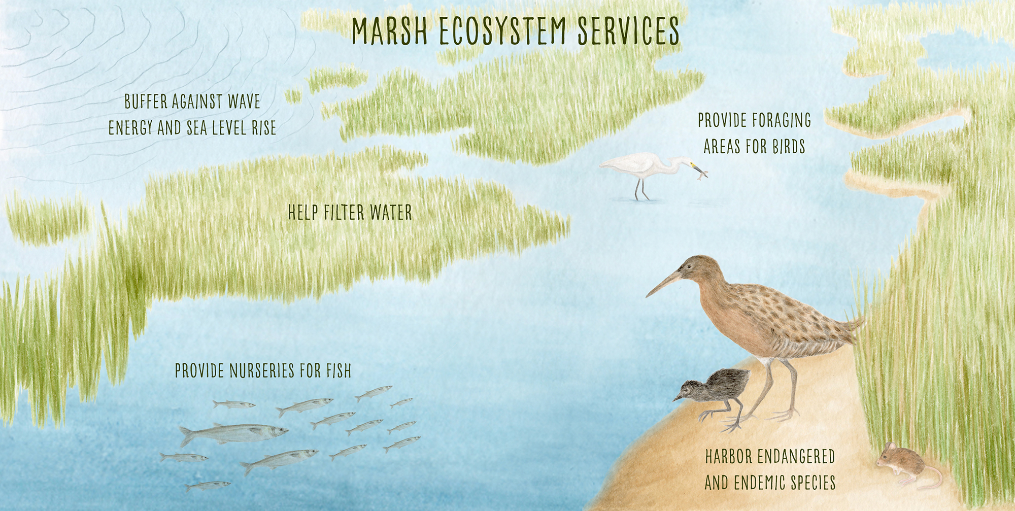
Tidal marshes provide food, shelter and resources to local species, as well as recreation opportunities for humans. The pictured benefits are only a snippet of the full array of resources marshes provide. (IMAGE CREDIT: Hannah Kanne)
Some of these marshes formed 2,000 years ago. Even as recently as 1800, these ecosystems filled an estimated 190,000 acres of the Bay. Yet, by the turn of the 21st century, 80% of the historic marshes had succumbed to human development and pollution, the lost area larger than the city of Chicago.
For decades, researchers have combed through remnants of the marshes’ past to discover elusive historical baselines for these dwindling ecosystems. But the road to restoration is tricky: Historical records of the Bay’s marshes are often sparse, fractured by past occupants degrading the habitats without ecological consideration or documentation. That’s why scientists combine these ecological histories with current research to create accurate reclamation plans for tidal marshes and save the wildlife species — and human populations — that rely on them.
It’s a race against time to fortify these ecosystems, which serve as resilient natural buffers against waves, before seas rise too much. Without these protections, the Bay’s pervasive system of highways, towns and cities — some built directly on top of historic marshes — will grow ever more vulnerable to sea level rise.
Unveiling the Ecological Past
Before the San Francisco Bay was the largest estuary on the West Coast, it was home to Indigenous populations for thousands of years. The Pacific Ocean invaded the low-lying areas of the present-day Bay around 10,000 years ago, making it a relatively new estuary compared to those that formed after the last ice age. Tidal marshes formed along the shores between 2,000 and 3,000 years ago, extending up to the Central Valley, where California’s two largest rivers — the San Joaquin and the Sacramento — dump into a delta.
Early native inhabitants of the Bay harvested fish, wildlife and plants from these productive habitats and actively managed them for hundreds of years, said Josh Collins, the recently retired lead scientist of the San Francisco Estuary Institute that focuses on researching California ecosystems. Indigenous communities forged salt ponds that led to salt trade across the Sierra Nevada. Further up the estuary, they altered freshwater tidal marshes to aid waterfowl hunting. And various lakes lining the edge of the Bay were forged by indigenous hands as shallow reservoirs for periods of drought. These changes to the Bay weren’t large-scale enough to compromise its ecological outputs — unlike the changes brought by generations of settlers to follow.
“To the south, the sea-arm or estuary turns into great numbers of other inlets, and I suppose lakes as well. I had a clear view of it, and it looks like a maze.” — an 18th-century Spanish exploratory expedition describing the South Bay marshes (Stanger, F. M., and A. K. Brown, 1969)
Spanish settlers were among the first Europeans to arrive in the 1770s. They brought Mediterranean plants spread like wildfire in the relatively untouched Bay landscapes. This marked the first instance of ecological invasion that would forever change the area’s landscape, Collins said, resulting in “the most invaded bay in the world” with hundreds of invasive species.
As the Spanish began establishing missions in the delta, they disrupted thousands of years of careful, small-scale ecological management — all but eliminating the indigenous practice of prescribed fires. The settlers logged forests and let their cattle munch on vegetation along riverways. This increased erosion, which flooded the Bay with dirt; the adaptable tidal marshes surged in size from the newfound sediment. Extensive overgrazing continued until the Mexican War of Independence marked the decline of Spanish missions around 1821.
But the Bay would never be the same following the discovery of gold in California in 1848.
“The Gold Rush changed everything almost overnight,” Collins said. “Nobody was thinking about wildlife or trying to preserve anything — they were just provisioning people during a massive, unprecedented economic boom on the west coast of the continent.”
The 1,000-strong population of San Francisco spiked to 25,000 in a mere year. New residents around the Bay filled, drained and diked marshlands by the tens of thousands of acres — “whatever they could do to put people places,” Collins said. People built farms, facilities, transportation centers and levees on top of filled wetlands. Areas lacked sewage treatment or runoff control, polluting the Bay and its remaining marshes. Gold hunters used water cannons to blast sides of rivers and hillsides to look for bounty; the resulting sediment choked and flooded the Sacramento Valley.
As populations exploded in the late 1800s, so did salt pond creation in the South Bay. Salt seekers diked and exploited large swaths of marsh to collect salt left behind by evaporating water. At the height of production, salt ponds covered about 36,000 acres around the Bay. The agricultural giant Cargill — the largest privately held corporation held in the U.S. — still operates salt ponds in the Bay to this day.
Gold hunters, military presence and thousands of newfound residents recklessly polluted the San Francisco Bay over time — a tainted history still trapped in layers of sediment, Collins said. According to the San Francisco Estuary Institute, occupants diked 137,000 acres of wetlands and filled 50,000 acres.
As of 1999, only 16,000 acres of historic marshland remained in the San Francisco Bay. An additional 24,000 acres of new marshes naturally evolved, but these young habitats lacked the rich biodiversity and ecosystem services of their predecessors.
“You don’t just go create an ancient marsh. Building all the ecosystem services takes about 250 years,” Collins said.
Historical tidal marshes that once flourished under indigenous care now lie beneath airports, parking lots, roadways and neighborhoods in concrete graves. Although past habitats may have been desecrated, they’re not forgotten, researchers insist. To save the remaining wetlands, teams reconstruct ancestral ecosystems and use this knowledge to ensure the future of the Bay Area.
Putting the Past to Paper
Deep in the California Academy of Sciences vaults, tucked within a maze of shelved history, Alex Rinkert hunched over a desk. The fluorescent lights beaming overhead illuminated the specimen he inspected: a bird nest collected in 1909.
After snapping pictures at every angle, he delicately snipped pieces from the nest, then weighed and added them to small test tubes. By the time his sampling concluded, these tubes numbered in the hundreds — all remnants from historical plant communities. These nests, which his team calls “botanical time capsules,” will provide insights from transitional habitat long lost from the Bay’s fringes.
“It’s interesting thinking about what transitional habitat was because we can’t really see that anymore,” said Rinkert, a senior biologist with the San Francisco Bay Bird Observatory. “It makes me want to try and conserve whatever we have left because we’ve lost so much already.”
The early invasion of nonnative plants in the San Francisco Bay — long before people thought to document natural occupants — thwarted the area’s historical baselines, said Justen Whittall, a biology professor at Santa Clara University and collaborator on the bird nest project. That’s why today’s researchers, including Rinkert, must get creative to peer into the past.
Rinkert’s research relies on nests from birds that traditionally made their homes in transitional habitat that border marshlands, such as tidal marsh song sparrow subspecies and savannah sparrows. Each nest sample contains unique “barcodes” of plant species, Whittall said. The scientists sequencing these samples are akin to grocery store cashiers, scanning items and creating receipts of the different plants within each sample. By identifying the building blocks of the nests, researchers can gather clues about early plants from long-gone communities and help the restoration accuracy of the San Francisco Bay Bird Observatory projects that revitalize transitional habitat to protect local bird populations, he said. Preliminary results from their proof-of-concept experiment revealed remnants of a California rose bush in a 112-year-old nest, demonstrating that their new method of identifying plants from bird nests is successful.
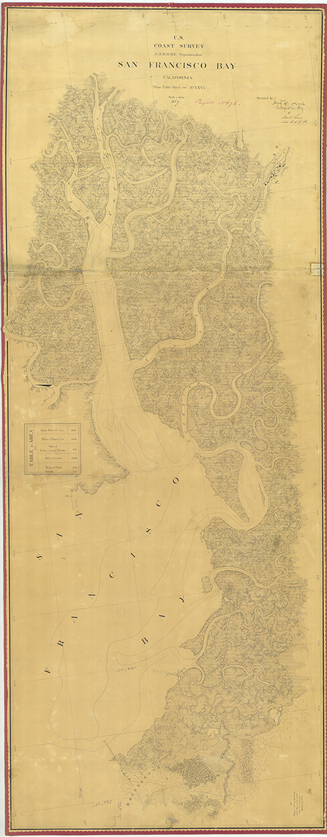
1857 U.S. Coast Survey topographic sheet of southern San Francisco Bay, Rodgers and Kerr 1857. (Courtesy National Ocean Service)
This uncovered data will add to information researchers have carefully extracted from the past. Archival herbariums, for instance, are historical guidebooks for local plant life that emerged in the 1920s, Melen said, when botanists decorated large sheets of paper with species at different phases of life to help people identify plants. These records aren’t always precise, though, and don’t date back far enough for a proper historical snapshot.
To get a better idea of the large-scale progression of coastal degradation, historians refer to documents called “T-sheets.” These are maps created by the U.S. Coast Survey between 1851 and 1900, shortly after the Gold Rush and long after colonists first arrived to the Bay. T-sheets remain unparalleled in terms of accuracy and detail for that time period, said Sean Baumgarten, who works with the San Francisco Estuary Institute’s historical ecology program.
Earlier than these maps, the available information gets more piecemeal, Baumgarten said. The San Francisco Estuary Institute compiles historical resources — maps, photos, texts, articles and more — to re-create what squandered landscapes might’ve looked like before European arrival. Teams scour archives to collect data, organize it and then share it for widespread use, typically through maps that display ecology before the California’s European colonization. For any given project, this means sifting through thousands of documents to verify information, a process spanning three years on average.
“There are things that are in some drawers at a local historical society archive that nobody’s seen for decades, so that would be much more sort of a higher level of effort to uncover those data sources and clues,” Baumgarten said.
Understanding the rich ecological history infused in the marshlands — and their deterioration — can help researchers establish restoration targets that mimic ancient habitats. But gaps in this biography of the Bay force researchers to use a blend of the past and present to chart the future of these ecosystems.
Combining the Past with the Present
Gravel tumbled under her shoes as Jesse McKeen-Scott walked from site to site within the Eden Landing Ecological Preserve, a soft breeze pushing the smell of salt through the air. The raised road she ambled across was a berm created decades ago from dredged marshlands. Now, marked with tire lines from years of vehicle usage, the levee carries researchers like herself across reemerging marsh ecosystems where they can help these habitats blossom once more.
“I think it’s really important to consider that the work that we’re doing now is really going to protect these coastlines and communities in the future,” said McKeen-Scott, the restoration program manager for Save the Bay. “That community includes the humans, wildlife and plants that can hopefully coexist with the work we’re doing.”
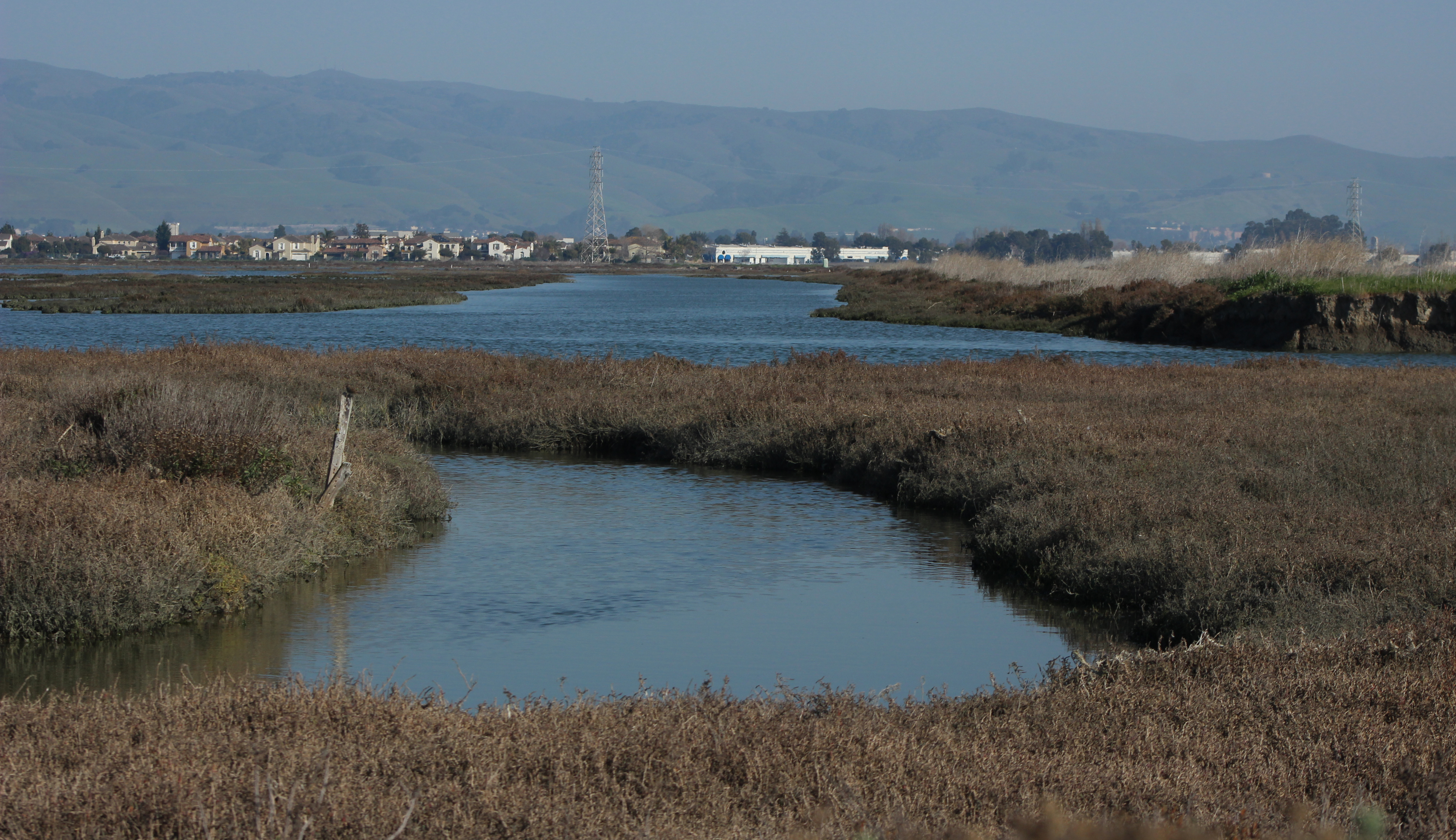
The Eden Landing Ecological Reserve is made up of about 6,400 acres of restored salt ponds, diked marshes and transitional habitat. (Credit: Brittney J. Miller)
Save the Bay, the oldest Bay restoration organization founded in 1961, is one of many groups dedicated to reclaiming that future for the San Francisco Bay’s wetlands. Teams draw from the emerging historical data to guide their restoration projects — but it’s often not enough information to fill in all the gaps left from centuries of ecological abuse.
Even if it was wholly available, researchers couldn’t solely rely on historical knowledge for habitat restoration, Mckeen-Scott said. Dealing with the short, steep and manmade berms that checkerboard across most of today’s marshes is different than dealing with the natural historic berms that gradually sloped for miles. That’s why restoration plans must curate the right combination of historical data and evolving current baselines to cater to ever-changing environmental conditions while maintaining past ecosystem diversity.
“It’s an interesting dialogue between all the land managers because we’re all trying to figure out what’s going to do well in what is essentially a novel ecosystem that’s been created,” said Isaiah Thalmayer, a senior project manager at Point Blue Conservation Science. “It’s a process of trial and error.”
For instance, research teams at the San Francisco Bay Bird Observatory and Save the Bay do use historical nuggets to guide what species belong in transitional habitat and what zones should be targeted. But information about these zones is especially sparse, said David Thomson, a former senior ecologist at the San Francisco Bay Bird Observatory. His mapping and ranking system for transitional zone restorations in the Bay estimated the historical bounds of transitional habitat, which reportedly stretched miles between upland and intertidal habitats. The research noted that very few reference sites — or pieces of pristine habitat that are still historically accurate — survived the decades of development. Even those that persist are still a product of human land management to some degree, according to Thomson. That makes relying solely on past plant communities to guide restoration in these habitats nearly impossible.
“The natural wonderland without human influence? It’s not a thing,” he said.
As a result, researchers need to combine “investigative work” about historical plant species with today’s species distribution, Thomson said. They do this by surveying existing plant diversity near restoration sites, rather than only relying on communities from the past. For instance, Save the Bay researchers collect seeds from areas as close to target restoration areas as possible, picking hearty plants that would provide native diversity. With these current baselines, the organization can create up-to-date plant lists for projects, said Jessie Olson, Save the Bay’s habitat restoration manager.
While these projects focus on the steep berms that encircle salt ponds other restorations target the salt ponds themselves — specifically, their capacity to be transformed back into productive salt tidal marshes. To do so, construction teams directed by the South Bay Salt Pond Restoration Project — a partnership focused restoring tidal wetlands — must rip holes into decades-old levees, letting Bay water gradually filter through the briny waters until they can support marsh communities once again.
-
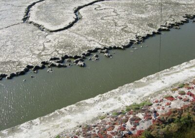
Salt pond one year after restoration. (Credit: kite aerial photography from Cris Benton and taken under a Special-Use Permit from the U.S. Fish and Wildlife Service)
-
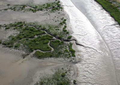
Salt pond four years after restoration. (Credit: kite aerial photography from Cris Benton and taken under a Special-Use Permit from the U.S. Fish and Wildlife Service)
-
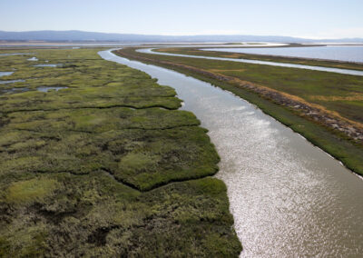
Salt pond eight years after restoration. (Credit: kite aerial photography from Cris Benton and taken under a Special-Use Permit from the U.S. Fish and Wildlife Service)
As executive project manager of the project, Dave Halsing must coordinate difficult decisions with every pond. For example, Facebook’s main campus in Menlo Park sits adjacent to a batch of ponds. Make one wrong hole, and the headquarters of one of the largest corporations in the world could flood.
“It really does show how jammed together this developed Bay Area interface is and how much stuff we’re cramming into a pretty small area in the grand scheme of things,” he said.
Like projects in transitional habitat, dealing with marshland demands a similar combination of historical and current baselines. To understand more about the historical marshes these salt ponds carved into, researchers first refer to historical maps, photos and sketches of the area, Halsing said. They trace the past through written logs of the area’s development and the transactions of these unrealized essential habitats. They also compare San Francisco marshes to wetlands elsewhere to understand how marshes without histories of salt production are supposed to look.
These historical nuggets serve as a decent guide for what a healthy restored marsh might look like once levees welcome Bay water into salt ponds once again. But beyond the general morphology and species that could be found in the ecosystems, more specific baselines can be a mystery — one supplemented by current baselines.
Before the projects even began, researchers did what historical inhabitants didn’t think to do: collect rigorous baseline environmental conditions for these habitats. They measured the different species, their population size, water quality conditions and more to better track each site’s success, Halsing said. These pre-project conditions, including 25 specific biological impacts, serve as the monitoring standards to ensure habitats don’t decline amidst restoration. Long-term monitoring will help researchers decipher what successful combinations of historical and current data to implement into future plans.
“The world is not even the same as it was 15 or 20 years ago,” he said. “The things we knew to be true, even a decade ago — we think they’re still mostly true, but the rates are changing.”
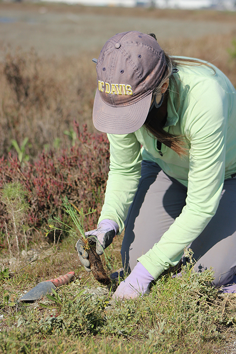
A Save the Bay volunteer plants a sapling into a transition zone at Eden Landing Ecological Reserve. (Credit: Brittney J. Miller)
A Future Threat
On a clear day at Eden Landing, Dianne Neal planted a California poppy into the transitional habitat. The flower joined hundreds of other new arrivals in the dirt.
Kneeling on the ground, hands clasped around the sapling, Neal looked like she was praying for the future of this ecosystem. It was a day of learning and of celebration: The following week would mark her seventh year volunteering with Save the Bay.
“It’s a way that I can contribute to what we see around us, as far as climate change and environmental awareness,” Neal said. “When my friends and family ask, ‘What are you doing today?’ I say, ‘I’m saving the Bay.’”
The Bay was calm that day, slowly breathing into the marshes at high tide and gradually exhaling. But other days, the Bay roars with winds and white-capped waves, pounding on the areas lining it. That’s why these habitats are so important: They take on a sponge-like role. When storms or king tides threaten shores with flooding events, these ecosystems can soak up the energetic water and squeeze it back out, dampening the ocean’s force and protecting shores.
These habitats are still protecting the cities that devastated them. But their ecosystem services only work if restored marshes take shape before rising sea levels encroach too much, researchers around the Bay insist. Each restoration project is further insurance to the future of the Bay Area and the 7.77 million people who call it home.
“We need those salt marshes, the mudflats and the entire bayland system,” Melen said. “We need all of that if we’re hoping to survive with our buildings and our concrete and all of our roads.”
© 2022 Brittney J. Miller / UC Santa Cruz Science Communication Program
Brittney J. Miller
Author
B.S. (biology) University of Florida
B.S. (journalism) University of Florida
Internships: The Monterey Herald, Knowable Magazine and Nature
“What do you want to do when you grow up?”
As a child, I writhed in discomfort when asked this question. My interests routinely shuffled between subjects: The personal chemistry set perched on my desk spelled a future in lab coats, but the notebooks tumbling from my closet—filled with half-written fables, poetic endeavors, and twisting tales—suggested otherwise. How was I expected to taper my curiosities to a single career?
This paradox of passions followed me through life like a shadow. In college, I tentatively paired journalism and biology majors to learn more about each discipline. By graduation, my experiences had coalesced to illuminate the perfect career: science journalism. It’s more than a job—it’s a promise to sate my mind’s wanderings and share them with the world.
Joshua Zupan
Illustrator
B.S. (ecology & evolutionary biology) University of California, Santa Cruz
B.A. (art) University of California, Santa Cruz
Joshua Zupan is a scientific illustrator and naturalist based in California. He completed his undergraduate studies at UC Santa Cruz, double majoring in Art (B.A) and Ecology & Evolutionary Biology (B.S.) before arriving in Monterey to pursue a Scientific Illustration Certification. Since childhood, Josh has found inspiration and excitement in exploring the natural world. Whether collecting rocks, photographing wildflowers and bugs, or exploring his backyard ecosystems, Josh can often be found doing the same things today as he did in his adolescence. Communicating his curiosity for natural history through scientific illustration carries a great sense of duty and fulfillment for Josh. He hopes to use scientific illustration as a tool to create accessible, educational material that excites people to learn about the ecosystems around them.
Hannah Kanne
Illustrator
B.F.A (studio art, emphasis in science illustration) The University of Georgia
Hannah is a science illustrator from Georgia. She received her B.F.A. in Studio Art with an emphasis in Science Illustration from The University of Georgia. Her desire to learn more brought her to California where she received her certificate in Science Illustration at CSUMB. Science illustration allows her to study and reflect the beauty and complexity of nature. Encouraged that there is always more to learn, she continues to work to expand her skills and interests so that she may inspire others to find the same love she has for the natural world that surrounds us.